Initially, the causeway was shared by a single track railway, and a single carriageway road. Not long afterwards a water pipeline was added. As Singapore's population increased it became increasingly dependent on Malayan water.
Before the war the causeway didn't change much, being quite adequate for the traffic on offer. From the 1960s onwards the causeway was gradually widened to take increased traffic and water, and today it is a multi-lane highway, always jammed with vehicles queuing for the customs posts at either end of the crossing.
The causeway's days may be numbered. There is already an alternative crossing - a suspension bridge - and proposals have been made to replace the causeway with a bridge. Petty politics have prevented progress. Singapore and Malaysia rarely agree about anything, and there is even a wacky scheme to replace the Malaysian side of the causeway with a bridge that joins the Singapore half of the causeway in the middle of the Straits.
| Before the causeway was built the only way across was by ferry. This is the Johore jetty in the early 1900s. |  |
| Some ferries were for passengers. Others were for railway wagons. This 1915 view shows the ingenious loading ramp at Woodlands, which allowed for variations in the tide. |  |
| This view shows the causeway under construction, early 1920s. I think this is the Woodlands end, looking towards Johore Bahru. |  |
| Woodlands end of the causeway shortly after opening. Mosquito buses waiting for fares. The railway appears to occupy most of the causeway. Later pictures show the road to the left of the railway. |  |
| A very early view of the causeway, looking towards Woodlands. The mosquito buses are, presumably, vying for pedestrian traffic. |  |
| The causeway blocked the straights, preventing ships from passing. However, a short canal was included at the Johore end, allowing small vessels to cut through. This view, taken around 1930, shows the lifting bridge that was raised to let boats pass. A train is entering Singapore. |  |
| From the Woodlands end in the 1940s, this scene seems incredible today. A couple of cars have the causeway to themselves, and there is no hint that a great city will one day arise at the opposite end. | 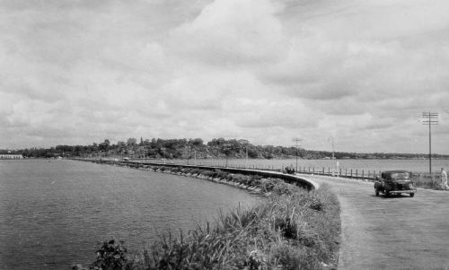 |
| My favourite causeway photo, probably taken in the late 1950s. Vintage car, vintage bus, vintage train. Perfect! |  |
| An aerial view from the 1950s. The water pipeline can be seen heading due South towards Singapore city, whilst the road and railway turn South-West towards Bukit Panjang and Bukit Timah.. |  |
| It's c1961, and we see a modern diesel loco taking an express towards Woodlands. Traffic is still light. The lifting bridge seems to have gone. | 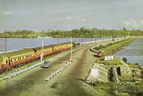 |
| Until the early 1960s there were very few formalities in crossing between Singapore and the mainland. After the separatation of Singapore from Malaysia, formal immigation and customs controls were introduced, much to the consternation of daily commuters. This is the Customs post at the Johore Bahru end of the Causeway, c1960. |  |
| Same view a few years later, and the customs post has been extended.. |  |
| This is the border control point at the Singapore end, 1967. |  |
| Now an arial view from above the Singapore Naval Base. Johore Bahru is a small town, and the Sultan's palace is prominent. |  |
| We jump forward to 2005. The causeway is now a multi-lane highway, and trucks are queueing the full length (and more). A short train is about to enter Singapore. There are now three pipelines, instead of just one. Johor Bahru is a major city. Even the Johor customs post is the size of a small town. |  |
| Finally an image from Google Earth. |  |

.jpg)

Hi there! Do you own the 2005 image? I would like to make an inquiry :)
ReplyDelete